Sunday, May 28, 2006
Martinez to Benicia Ferry
a license was granted to Oliver C. Coffin (ominous name!) to establish a ferry between Martinez and Benicia, after he had filed a bond in the amount of two thousand dollars. The court permitted him to charge the following fares: For each foot man, $1; man and horse, $2.50; single horse, mule or ox, $2; wagon, $5; carriage, $4; each head of sheep or hogs, 50 cents.


A Problem for Beets
AP Wire 05/27/2006 Farming outlook grim for Pembina County: "'If you can't plant land until June 1, sugar beets and canola are out, and you lose 20 percent of your yield potential on wheat,' Symington said. 'This situation devalues our land because it limits what you can plant.'"
Thursday, May 25, 2006
Friends of the Library Cookbook
The friends of the Crockett library have completed their cookbook project. We have them for sale at the Museum for $14.
Monday, May 22, 2006
Archaeologists uncover lost era
Archaeologists uncover lost era: "BRENTWOOD: John Marsh House dig reveals American Indian artifacts dating back 9,000 years
By Tanya Rose
CONTRA COSTA TIMES
Archaeologists scouring the historic John Marsh House-Cowell Ranch site in Brentwood say there are American Indian artifacts and bones buried within the soil, some dating back as far as 9,000 years to the 'Paleo-Indian' era."
Wow! 9000 years.
By Tanya Rose
CONTRA COSTA TIMES
Archaeologists scouring the historic John Marsh House-Cowell Ranch site in Brentwood say there are American Indian artifacts and bones buried within the soil, some dating back as far as 9,000 years to the 'Paleo-Indian' era."
Wow! 9000 years.
Crockett Day in the Park
Memorial Day, Monday May 29, is always celebrated by the Museum and Historical Society. About 150 Crockett veterans and their families will stop by the Museum for refreshments and conversatio. Between 1 and 3 pm, the Generation Gap Band will play in Rithet Park. Given $3 gasoline, stay home, come to the Museum. Admission is always free.
Crockett Still Sets Records
Crockett sets rainfall record: "Crockett set a record today for annual rainfall, according to the town's official weather watcher, Karen 'Dejah' Dorantes.
'Ta-dah, we broke it,' Dorantes said.
The old mark of 30.51 inches, set back in 1957, fell at exactly 2:22 p.m., Dorantes said. It happened during an intense hour of rain that lasted until almost 3 p.m.
'We had a huge downpour right around 2 o'clock this afternoon,' Dorantes said. 'The skies just opened up.'
At 6:20 p.m. today, the total stood at 31.18 inches for the July 1 to June 30 period.
'We had not budged an inch since the beginning of May,' said Dorantes, who monitors Crockett's weather for KTVU Fox 2. There was measurable rainfall Friday, Saturday and today, she said.
Crockett's weather record applies only to 'recorded' history. There is a hiatus from 1977, when the National Weather Service decommissioned Crockett as a weather-monitoring post, until last year, when Dorantes became the TV weather watcher."
'Ta-dah, we broke it,' Dorantes said.
The old mark of 30.51 inches, set back in 1957, fell at exactly 2:22 p.m., Dorantes said. It happened during an intense hour of rain that lasted until almost 3 p.m.
'We had a huge downpour right around 2 o'clock this afternoon,' Dorantes said. 'The skies just opened up.'
At 6:20 p.m. today, the total stood at 31.18 inches for the July 1 to June 30 period.
'We had not budged an inch since the beginning of May,' said Dorantes, who monitors Crockett's weather for KTVU Fox 2. There was measurable rainfall Friday, Saturday and today, she said.
Crockett's weather record applies only to 'recorded' history. There is a hiatus from 1977, when the National Weather Service decommissioned Crockett as a weather-monitoring post, until last year, when Dorantes became the TV weather watcher."
Wednesday, May 17, 2006
Preservation Online: Today's News Archives: Oakland Preservationists Open Doors to Threatened Victorian House
Preservation Online: Today's News Archives: Oakland Preservationists Open Doors to Threatened Victorian House: "Lushly decorated in the high Victorian style, the interior of the Cohen-Bray house in Oakland, Calif., is a must-see. Unfortunately, the 122-year-old structure is so fragile—compromised by a shaky foundation, leaky roof, and water damage—that it is usually closed to the public. On May 21, however, Cohen-Bray's board of directors will offer visitors a rare glimpse inside the house to shed light on current preservation efforts there. "
Tuesday, May 16, 2006
American Bridge awarded Bay Bridge span deal - East Bay Business Times:
American Bridge awarded Bay Bridge span deal - East Bay Business Times:
What we ought to do is sell all the bridges and revert to the old electric trains.
What we ought to do is sell all the bridges and revert to the old electric trains.
Saturday, May 13, 2006
Before The Fall
Ninety years ago, as the month of June 1916 began, residents of Crockett, Valona, Selby and Port Costa looked forward to the anticipated joys of the coming summer season. The John Swett Senior Class dance and entertainment held at the Crolona hall on Loring was, according to the weekly Signal, “a big success.” The John Swett champion baseball team ended its season by winning every game against other schools in the county league. In honor of the champions, the student body gave the team a banquet at the Venus Café. The newspaper reporter, in the paper’s June 2nd issue, wrote “Crockett is certainly invincible when it comes to sportsmanship, or anything else for that matter, where skill and endurance is concerned.”
Monday, May 08, 2006
Before the Carquinez Bridge
For those who are curious about how folks crossed the Carquenez in the days before 1927:
The Solano and Contra Costa were the World's Largest Train Ferries and operated between 1879 - 1930. They ferried passenger and freight trains for one mile across the Carquinez Strait between Benicia (Army Point) and Port Costa (known earlier as South Benicia or Bull Valley). The ferryboats were named after the two counties served by the ferryboats as Benicia was located in Solano County and Port Costa was located in Contra Costa County.
The Solano was 424 feet long and 116 feet wide and were capable of carrying entire passenger trains or a 48-car freight train and locomotive. It was built in Oakland, California in 1878.
The Contra Costa was built in 1914 due to increased traffic over the line and the need for a second ferryboat. It was slightly larger and wider than the Solano.
Original traffic levels over the line could not justify the large capital expense of a long railroad bridge across the Carquinez Strait. However, by 1927 the two ferries were working at their maximum capacity. On May 31, 1928 the Southern Pacific authorized construction of the railroad bridge at Benicia. The bridge was completed eighteen months later and was formally dedicated on November 1, 1930. The bridge is 5,603 feet long and runs from Suisun Point (Martinez) to Army Point (Benicia).
The opening of the bridge marked the end of the ferry service at Benicia. According to historian Jerry Bowen, "(The) Solano was dismantled and the hull sank and rotted away at Morrow Cove (located at the California Maritime Academy in Vallejo). The Contra Costa was dismantled at Oakland and sold for junk."
The Solano and Contra Costa were the World's Largest Train Ferries and operated between 1879 - 1930. They ferried passenger and freight trains for one mile across the Carquinez Strait between Benicia (Army Point) and Port Costa (known earlier as South Benicia or Bull Valley). The ferryboats were named after the two counties served by the ferryboats as Benicia was located in Solano County and Port Costa was located in Contra Costa County.
The Solano was 424 feet long and 116 feet wide and were capable of carrying entire passenger trains or a 48-car freight train and locomotive. It was built in Oakland, California in 1878.
The Contra Costa was built in 1914 due to increased traffic over the line and the need for a second ferryboat. It was slightly larger and wider than the Solano.
Original traffic levels over the line could not justify the large capital expense of a long railroad bridge across the Carquinez Strait. However, by 1927 the two ferries were working at their maximum capacity. On May 31, 1928 the Southern Pacific authorized construction of the railroad bridge at Benicia. The bridge was completed eighteen months later and was formally dedicated on November 1, 1930. The bridge is 5,603 feet long and runs from Suisun Point (Martinez) to Army Point (Benicia).
The opening of the bridge marked the end of the ferry service at Benicia. According to historian Jerry Bowen, "(The) Solano was dismantled and the hull sank and rotted away at Morrow Cove (located at the California Maritime Academy in Vallejo). The Contra Costa was dismantled at Oakland and sold for junk."
Thursday, May 04, 2006
Local History
A couple of pertinent quotes from:
Ronald Limbaugh, Ph.D.
Emeritus Professor of History, University of the Pacific
“Preserving the raw material of history is one of the most important roles of local historical societies and libraries, for without documentation, history can truly become, as iconoclast John Dos Passos once said, “a mass invention, the daydream of a race.” (p.17, Summer 2005, California Historian)
“Regardless of whether the subject is the Peloponnesian Wars or the Fresno Armenians, no matter if you are a trained professional or a gifted amateur, if you write history, make it meaningful by telling us not only what happened but why. Flesh out bare skeletons with real people living real lives. Record not just events but explain their context and significance. Give the story perspective, depth as well as breadth. Finally, tell the story in simple, direct, literate prose. Thucydides did all this, and his words are still very readable today.” (p. 18, Summer 2005, California Historian)
Ronald Limbaugh, Ph.D.
Emeritus Professor of History, University of the Pacific
“Preserving the raw material of history is one of the most important roles of local historical societies and libraries, for without documentation, history can truly become, as iconoclast John Dos Passos once said, “a mass invention, the daydream of a race.” (p.17, Summer 2005, California Historian)
“Regardless of whether the subject is the Peloponnesian Wars or the Fresno Armenians, no matter if you are a trained professional or a gifted amateur, if you write history, make it meaningful by telling us not only what happened but why. Flesh out bare skeletons with real people living real lives. Record not just events but explain their context and significance. Give the story perspective, depth as well as breadth. Finally, tell the story in simple, direct, literate prose. Thucydides did all this, and his words are still very readable today.” (p. 18, Summer 2005, California Historian)
Wednesday, May 03, 2006
Eye On The Bay
Today (May 3) the TV program "Eye on the Bay" brought their cameras and crew to C & H. The refinery will be included in an upcoming segement about factories and refineries around the San Francisco/San Pablo Bays.
Monday, May 01, 2006
Juan Bautista de Anza
Explorers Juan Bautista de Anza Blazed the Anza Trail
Juan Bautista de Anza was the first European to establish an overland route from Mexico, through the Sonoran Desert, to the Pacific coast of California. New World Spanish explorers had been seeking such a route through the Desert Southwest for more than two centuries. Born in Mexico in 1736, Anza joined the army in 1752 and served on the northern frontier of Sonora. In 1774, he led a small expedition from the presidio at Tubac (now in Arizona) to the mission at Monterey, California. The following year, he led a second colonizing expedition with livestock and more than 200 people, to establish the mission and presidio at, what would become, San Francisco. At the time of Anza's first expedition, the English still called California New Albion, the Russians were stalking the Pacific Northwest coast and the American Revolution was still years away. But starting in 1768, the Spaniards had already established a series of presidios and missions along the California coast as far north as Monterey.
……..
Upon his arrival back in Tubac on May 26, after traveling more than 2,000 miles, Anza immediately began plans to return to Alta California with a colonizing expedition. Colonizing Expedition A year later, after receiving permission and funding from Viceroy Bucareli in Mexico City, Anza began organizing his second expedition in the fall of 1775. Authorized to colonize the San Francisco Bay area by transporting 38 families, together with livestock and soldiers, he began to recruit from among the poor in Culiacan, 600 miles south of Tubac. The assembled expedition finally left from Tubac on October 23, 1775, with 245 people (155 of them women and children), 340 horses, 165 pack mules, 302 cattle. Father Pedro Font was selected to accompany this expedition, because of his expertise with navigation, along with a number of soldiers, 28 of whom would remain at the presidio once it was built in the San Francisco Bay region. The diary Font kept remains one of the great historical documents of the time. … Unlike the first expedition, they headed due west past Pilot Knob, arriving again at Yuha Wells on December 11. From there, this expedition followed the same route to San Gabriel Mission as the first expedition. After a freak desert snowstorm killed a number of their livestock, they headed up Coyote Canyon, going through San Carlos Pass on December 26. They arrived in San Gabriel on January 4, 74 days after leaving Tubac and 8 months after leaving Culiacan, the principle point of assemblage. He had succeeded in leading an enormous expedition safely to its destination through 1,800 miles of desert wilderness. On February 17, Anza and his expedition resumed their march north, traveling the familiar El Camino Real to Monterey, where they safely arrived on March 10. While the colonists remained there, Anza with Font and a squad of soldiers spent the following month exploring the San Francisco Bay area. Before leaving, Anza designated the future site of both the San Francisco Presidio and Mission Dolores. On April 13, 1776, Juan Bautista de Anza left Monterey and returned to Tubac. On June 17, the colonists left Monterey to sew the seeds for the city of San Francisco. Two weeks later on July 4, 1776, the 13 American colonies on the eastern shore of North Åmerica formally declared their independence from England.
Postscript: Upon his return to Sonora, Juan Bautista de Anza Anza was named governor of New Mexico. He died 12 years later on December 19, 1788 and was buried in Arizipe, Sonora, Mexico. Although rivals attempted to discredit his achievements, Anza's legacy is well established in history. He opened the overland corridor to the Pacific Southwest and had a primary role in the European settlement of California. Anza arrived in California with two more people than he had left with. Three children were born along the way; one woman died in childbirth. This almost doubled the population of California. The colonists who traveled the Anza Trail also gave birth to the cities of Los Angeles, San Francisco and San Jose. Their cattle and horses provided the foundation stock for the vast herds that would establish the great ranchos of California in the following years. In 1990, U.S. Congress created the Juan Bautista de Anza National Historic Trail, comprising the overland route of the colonizing expedition from Tubac, Arizona to San Francisco, California. -- Bob Katz [Crockett should have been on the trail - but it's not. Keith]
Juan Bautista de Anza was the first European to establish an overland route from Mexico, through the Sonoran Desert, to the Pacific coast of California. New World Spanish explorers had been seeking such a route through the Desert Southwest for more than two centuries. Born in Mexico in 1736, Anza joined the army in 1752 and served on the northern frontier of Sonora. In 1774, he led a small expedition from the presidio at Tubac (now in Arizona) to the mission at Monterey, California. The following year, he led a second colonizing expedition with livestock and more than 200 people, to establish the mission and presidio at, what would become, San Francisco. At the time of Anza's first expedition, the English still called California New Albion, the Russians were stalking the Pacific Northwest coast and the American Revolution was still years away. But starting in 1768, the Spaniards had already established a series of presidios and missions along the California coast as far north as Monterey.
……..
Upon his arrival back in Tubac on May 26, after traveling more than 2,000 miles, Anza immediately began plans to return to Alta California with a colonizing expedition. Colonizing Expedition A year later, after receiving permission and funding from Viceroy Bucareli in Mexico City, Anza began organizing his second expedition in the fall of 1775. Authorized to colonize the San Francisco Bay area by transporting 38 families, together with livestock and soldiers, he began to recruit from among the poor in Culiacan, 600 miles south of Tubac. The assembled expedition finally left from Tubac on October 23, 1775, with 245 people (155 of them women and children), 340 horses, 165 pack mules, 302 cattle. Father Pedro Font was selected to accompany this expedition, because of his expertise with navigation, along with a number of soldiers, 28 of whom would remain at the presidio once it was built in the San Francisco Bay region. The diary Font kept remains one of the great historical documents of the time. … Unlike the first expedition, they headed due west past Pilot Knob, arriving again at Yuha Wells on December 11. From there, this expedition followed the same route to San Gabriel Mission as the first expedition. After a freak desert snowstorm killed a number of their livestock, they headed up Coyote Canyon, going through San Carlos Pass on December 26. They arrived in San Gabriel on January 4, 74 days after leaving Tubac and 8 months after leaving Culiacan, the principle point of assemblage. He had succeeded in leading an enormous expedition safely to its destination through 1,800 miles of desert wilderness. On February 17, Anza and his expedition resumed their march north, traveling the familiar El Camino Real to Monterey, where they safely arrived on March 10. While the colonists remained there, Anza with Font and a squad of soldiers spent the following month exploring the San Francisco Bay area. Before leaving, Anza designated the future site of both the San Francisco Presidio and Mission Dolores. On April 13, 1776, Juan Bautista de Anza left Monterey and returned to Tubac. On June 17, the colonists left Monterey to sew the seeds for the city of San Francisco. Two weeks later on July 4, 1776, the 13 American colonies on the eastern shore of North Åmerica formally declared their independence from England.
Postscript: Upon his return to Sonora, Juan Bautista de Anza Anza was named governor of New Mexico. He died 12 years later on December 19, 1788 and was buried in Arizipe, Sonora, Mexico. Although rivals attempted to discredit his achievements, Anza's legacy is well established in history. He opened the overland corridor to the Pacific Southwest and had a primary role in the European settlement of California. Anza arrived in California with two more people than he had left with. Three children were born along the way; one woman died in childbirth. This almost doubled the population of California. The colonists who traveled the Anza Trail also gave birth to the cities of Los Angeles, San Francisco and San Jose. Their cattle and horses provided the foundation stock for the vast herds that would establish the great ranchos of California in the following years. In 1990, U.S. Congress created the Juan Bautista de Anza National Historic Trail, comprising the overland route of the colonizing expedition from Tubac, Arizona to San Francisco, California. -- Bob Katz [Crockett should have been on the trail - but it's not. Keith]
Sunday, April 30, 2006
Congressman Miller visits John Swett High School's "Student Creek Restoration Project"
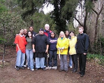
January 3, 2006
Even the biggest storm to hit California in 20 years could not stop Congressman Miller and students from the “Water and Environment” class at John Swett High School in Crockett from their plans to restore Edward Creek located directly behind their school. On January 3, 2006, George joined the team of ten students, and their teacher, Ms. Meilin Duncan, to get the densely wooded area ready for habitat restoration. George and the students worked diligently in the rain clearing the riparian zone (the area around the creek) by identifying, collecting and removing invasive non-native plants and replacing them with native coast live oak trees. The class hopes that their efforts will eventually bring back endangered Monarch butterflies and become a sanctuary for other native California wildlife.
The team was led by Sandra Dare and Karina Korde of the Carquinez Regional Environmental Education Center (CREEC). CREEC is a nonprofit that educates students about the environment and encourages communities to volunteer in creek restoration along the Carquinez Strait. CREEC has worked with the class for over a month on the restoration project.
South Vallejo View toward Crockett 1868-1869

Strait of Carquennes, from South Vallejo, 1868–69Carleton E. Watkins (American, 1829–1916)Albumen silver print from glass negative; 15 7/8 x 20 11/16 in. (40.3 x 52.5 cm)Gilman Paper Company Collection (L.1995.2.160)
When Watkins exhibited his mammoth prints in 1869, a critic remarked, "They justly deserve the encomiums passed upon them. For clearness, strength, and softness of tone, these picturesque views are unexcelled; and while they present truthful representations of the scene chosen, they are an earnest of the artistic skill of the photographer." The site of this photograph (known today as the Carquinez Strait) is a narrow, tidal body of water twenty miles inland from the mouth of San Francisco Bay. Part of a busy, deep-water shipping channel to Sacramento, the strait (and the surrounding shoreland) is still beloved for its extraordinary beauty and diversity of wildlife and flora. The Star Flour Mills (center) is featured by Robert Louis Stevenson in The Silverado Squatters (1883), his prescient travelogue about the California wine country of Napa Valley. Stevenson's account of his 1880 honeymoon discusses his journey from San Francisco to Calistoga and Mount Saint Helena, where he and his new wife and stepson lived for two months as "squatters" in the bunkhouse of an abandoned mining camp.
C&H From the WSW

When crossing the Carquinez, this is the sign seen from the bridge. Since the new owners took over, the sign has been turned on.
Thursday, April 27, 2006
World's largest cruise ship in Oslo
I'd like to see this ship sail into the Carquinez! At least it stopped in Norway - never to see it again.
There are 1,800 double rooms on the ship, and space for 4,370 passengers. A
crew of 1,360 are ready around the clock for their guests, and the vessel
includes a 136-meter long shopping avenue on board.
Wednesday, April 26, 2006
More Bridge Pictures

The Museum now has complete pictorial documentation of the lowering of the first section of the 1927 bridge from the time it began to being floated away on the barges. Anyone who wants to view them can drop by on Wednesday or Saturday.
Monday, April 24, 2006
The Crockett Bridge is Coming Down
Today, April 24, dismantling of the steel structure began. The first section is being lowered to a barge. So far they are a bit ahead of schedule in a job expected to take until September 2007.
Saturday, April 22, 2006
Crockett's Weatherpeople
After many years Crockett may again have an official weather station. This article was in this morning's West County Times.
Weather watcher revives tradition Crockett's official weather watcher waits for a record-breaking drizzle By Tom Lochner CONTRA COSTA TIMES
Karen "Dejah" Dorantes was set to post Crockett's all-time record for rainfall in a season when wet winter turned to sunny spring this past week, leaving her a fraction of an inch short.
"We just barely missed during this past rainstorm" over Easter weekend, said Dorantes, the official KTVU-TV weather watcher for Crockett since last year. "I thought we'd see the record fall." She's confident it will happen yet -- after all, the 2005-06 rainfall year ends June 30.
But after a record March, which saw 25 days of measurable precipitation in Crockett, and 10 rainy days out of 17 to start April, the climate has taken a turn for the better -- or worse, if you're chasing bad-weather records. A low-pressure system over the Pacific that appeared headed for a weekend Northern California landfall a week ago was falling apart by Friday, making a new record iffy -- for now.
Dorantes is undaunted.
"We will break the record; we're not done with the rain," she said. "We're at 30.26 (inches). We're very close. A quarter of an inch, that's all it's going to take, and the record falls."
"Come on, heavy weather," she coaxed. The record in Crockett's recorded history -- the qualifier is crucial -- is 30.51 inches, set in 1957.
Dorantes' husband, Rick, gave her a weather kit for her 50th birthday last year, rekindling a girlhood passion. "I've always enjoyed meteorology," she said. "It was one of my favorite sciences in high school and junior high school." The gift also revived a lost Crockett weather-watching tradition. From 1918 to 1977, Crockett was an official weather observation station for the U.S. government, said Keith Olsen, historian at the Crockett Historical Museum.
In those days, the official observation station was at C&H Sugar Co. In 1977, the National Weather Service determined the Crockett weather station needed new equipment. Instead of having it replaced, the government designated other stations in the area. The loss was not only Crockett's but science's. "The weather right here is a little different because of the location," Olsen said.
Dorantes agrees. "Crockett's a perfect observation post because it's at the mouth of the Carquinez Strait, just uphill from the Dead Fish (restaurant)" near the shore, she said. "Vallejo's weather station is way over the hills somewhere, in downtown. I'm closer to the water than they are." Soon after she got her weather kit, she called up KTVU Channel 2 and offered to become the Crockett weather-watcher. "They said, 'Sure.'" Her equipment includes a rain gauge and devices to measure wind direction, speed, humidity, air pressure and temperature. She does "Mornings on 2," rising at 4:30 every weekday morning to check her readings and her software, she said. "I e-mail my data in a few times during the broadcast, every few minutes if the weather's changing." She does it in part, she said, because "I felt Crockett was getting kind of ignored. Now, I get my shout out. Now, people know there is a Crockett."
In some future Crockett Meteorology Hall of Fame, Dorantes would stand shoulder-to-shoulder with a giant: the late, aptly-named Charlie Wind, who combined weather science with poetry. An instrument technician who retired from C&H Sugar Co. in the 1960s, Wind was Crockett's weatherman for about 30 years, Olsen said. "In the spring, when the swallows came back to the warehouse, Charlie would go through the whole plant and announce, 'Spring has arrived. The swallows have returned,'" Olsen said. "It would be like 'The Swallows of Capistrano,' Olsen said, alluding to the famous 1940 composition by songwriter Leon Rene. Like Capistrano's swallows, Crockett's would return on March 19 -- or around that date, Olsen said.
In an era when records are increasingly accompanied by asterisks, Crockett's, when it finally falls, will come with one, too. "The qualifier is 'recorded' history," Dorantes said.
That excludes 1977 to 2005. There were some wet spells in that span, notably 1981 to 1983, when rains washed out the Carquinez Scenic Drive east of Port Costa, cutting Crockett's direct road link to Martinez. National Weather Service statistics for Martinez show 32.94 inches of rain in the 1981-82 season; 36.28 in 1982-83; 33.85 in 1994-95; and 35.66 in 1997-98.
Could Crockett's 1956-57 total of 30.51 have been beaten in any of those years?
"Since there wasn't any weather observation," Dorantes said, "we'll never know."
Weather watcher revives tradition Crockett's official weather watcher waits for a record-breaking drizzle By Tom Lochner CONTRA COSTA TIMES
Karen "Dejah" Dorantes was set to post Crockett's all-time record for rainfall in a season when wet winter turned to sunny spring this past week, leaving her a fraction of an inch short.
"We just barely missed during this past rainstorm" over Easter weekend, said Dorantes, the official KTVU-TV weather watcher for Crockett since last year. "I thought we'd see the record fall." She's confident it will happen yet -- after all, the 2005-06 rainfall year ends June 30.
But after a record March, which saw 25 days of measurable precipitation in Crockett, and 10 rainy days out of 17 to start April, the climate has taken a turn for the better -- or worse, if you're chasing bad-weather records. A low-pressure system over the Pacific that appeared headed for a weekend Northern California landfall a week ago was falling apart by Friday, making a new record iffy -- for now.
Dorantes is undaunted.
"We will break the record; we're not done with the rain," she said. "We're at 30.26 (inches). We're very close. A quarter of an inch, that's all it's going to take, and the record falls."
"Come on, heavy weather," she coaxed. The record in Crockett's recorded history -- the qualifier is crucial -- is 30.51 inches, set in 1957.
Dorantes' husband, Rick, gave her a weather kit for her 50th birthday last year, rekindling a girlhood passion. "I've always enjoyed meteorology," she said. "It was one of my favorite sciences in high school and junior high school." The gift also revived a lost Crockett weather-watching tradition. From 1918 to 1977, Crockett was an official weather observation station for the U.S. government, said Keith Olsen, historian at the Crockett Historical Museum.
In those days, the official observation station was at C&H Sugar Co. In 1977, the National Weather Service determined the Crockett weather station needed new equipment. Instead of having it replaced, the government designated other stations in the area. The loss was not only Crockett's but science's. "The weather right here is a little different because of the location," Olsen said.
Dorantes agrees. "Crockett's a perfect observation post because it's at the mouth of the Carquinez Strait, just uphill from the Dead Fish (restaurant)" near the shore, she said. "Vallejo's weather station is way over the hills somewhere, in downtown. I'm closer to the water than they are." Soon after she got her weather kit, she called up KTVU Channel 2 and offered to become the Crockett weather-watcher. "They said, 'Sure.'" Her equipment includes a rain gauge and devices to measure wind direction, speed, humidity, air pressure and temperature. She does "Mornings on 2," rising at 4:30 every weekday morning to check her readings and her software, she said. "I e-mail my data in a few times during the broadcast, every few minutes if the weather's changing." She does it in part, she said, because "I felt Crockett was getting kind of ignored. Now, I get my shout out. Now, people know there is a Crockett."
In some future Crockett Meteorology Hall of Fame, Dorantes would stand shoulder-to-shoulder with a giant: the late, aptly-named Charlie Wind, who combined weather science with poetry. An instrument technician who retired from C&H Sugar Co. in the 1960s, Wind was Crockett's weatherman for about 30 years, Olsen said. "In the spring, when the swallows came back to the warehouse, Charlie would go through the whole plant and announce, 'Spring has arrived. The swallows have returned,'" Olsen said. "It would be like 'The Swallows of Capistrano,' Olsen said, alluding to the famous 1940 composition by songwriter Leon Rene. Like Capistrano's swallows, Crockett's would return on March 19 -- or around that date, Olsen said.
In an era when records are increasingly accompanied by asterisks, Crockett's, when it finally falls, will come with one, too. "The qualifier is 'recorded' history," Dorantes said.
That excludes 1977 to 2005. There were some wet spells in that span, notably 1981 to 1983, when rains washed out the Carquinez Scenic Drive east of Port Costa, cutting Crockett's direct road link to Martinez. National Weather Service statistics for Martinez show 32.94 inches of rain in the 1981-82 season; 36.28 in 1982-83; 33.85 in 1994-95; and 35.66 in 1997-98.
Could Crockett's 1956-57 total of 30.51 have been beaten in any of those years?
"Since there wasn't any weather observation," Dorantes said, "we'll never know."
Subscribe to:
Posts (Atom)